Friday, August 28, 2009

Flower Mound, Texas Identifies a Roadside Nuisance


Dan Jenkins once wrote that, "Nothing will turn you into an environmentalist faster than someone building a house that blocks your view of the lake." I believe he's right and that most activism is based in personal experience or belief. As mentioned elsewhere, when I began taking pictures of roadside park structures I did it simply because I liked the way the structures juxtaposed against their settings - particularly those in west Texas. I never really imagined a campaign to "save" any of the parks or structures. I named this blog more or less on a whim. However, the situation is changing.

It's a common story: expansion-minded local politicos decide they want to knock down a public place like a park so as to entice huge corporations to build exclusive neighborhoods with gated compounds protecting million dollar homes surrounded by acres upon acres of concrete retail all of which adds to the tax base which enables the local politicians to buy more land and tear down more green stuff in order to pave more parking lots ... ad nauseum. (I know, Joni Mitchell said it better in only nine words.)

Of course the local pols need something to "harrumph" about in order to justify and mask their destructive intentions so they trot out the local lawman with a fist full of evil statistics and a couple of the usual suspects, a loud chorus of "harrumphing" breaks out, a vote is taken and the deal is done. Another community facility is destroyed - for the good of the community.


Ok, Ok. I am getting way ahead of myself. The bull dozers are not skinning the earth here yet but it looks like they soon may be. And the civic leaders of Flower Mound only "harrumphed" themselves into adopting a resolution to ask TxDOT to close this site because, according to police Captain Wess Griffin, "Its antiquated and obsolete, families are not stopping there," and "it attracts a criminal element."


Joanna Dowling forwarded this article by Wendy Hundley published on August 15, 2009 by the Dallas Morning News entitled, "Flower Mound asks TxDOT to shut down picnic stop on I-35W." (Click on the headline above or cut and paste the link below.)

http://www.dallasnews.com/sharedcontent/dws/news/localnews/stories/DN-reststop_15met.ART0.State.Edition1.4c0abfc.html

I would like to mention to Captain Griffin and the others that, like me, not every traveler has a family or perhaps has the family along on the trip. What about truck drivers? They generally run solo. I am not a highly trained crime observer so maybe I didn't notice all the criminals hanging around when I took these pictures. Maybe the criminals are all in the great hiding places one finds here on the prairies.


I am not sure what the Captain means by "obsolete." What is so objectionable about a table and some shade from the hot Texas sun? Is a place to put your trash obsolete? Don't Mess with Texas, Captain. Unfortunately, Ms Hundley's article ran with only one photo; a black and white depicting a few pieces of trash outside a trash receptacle.


Antiquated? How about unique? I have more than 200 pictures of roadside picnic structures found within the State of Texas, and these in Flower Mound's jurisdiction are the only ones I have found to date that are shaped like the heads of longhorn cattle - which are certainly a Texas icon on the scale of say, the Alamo. At some point, someone obviously thought enough of this park to paint these structures in a Texas flag motif - a very unique and attractive touch by the way.

So I suspect there is more to the story. To get a better view of the broader issues here read the comments to Ms Hundley's article which follow the story at the above mentioned link. Ms Hundley's reporting and the readers comments are certainly worth your time and attention.


And although I mentioned in past entries that I didn't necessarily know that roadside parks in Texas were actually under any real threat, I appears that this one may well be. I will do some more research as time allows and post what I find out soon.

Tuesday, August 11, 2009

A couple of nights ago, I once again came across a design /architectural question regarding a roadside rest area and sent a quick email with attached photos to Joanna Dowling at www.restareahistory.com


As usual she promptly replied with an answer. The question basically revolves around the shelter design at a picnic area on highway 287 east of Wichita Falls, TX at a town called Jolly. Jolly is not much more than a truck stop and a small manufacturing plant at a crossroads, but here there is a spur off highway 287 (State Spur 47) and along that spur sits this roadside park.


The unique design of the picnic shelters here, sparked my question for Ms Dowling. Having no background in architecture or design, I rely entirely on things I have either read or heard or can research to have even the most basic of understanding of structures I observe.

As I explained to Ms. Dowling, I thought I remembered someone telling me way back when, that a structure of this type was called a hyperbolic paraboloid. I had absolutely know idea what that meant or what a design of that type entailed, but it sounded good, so I remembered it. Over the years, I had seen these picnic shelters sitting alongside 287 and wondered if they were indeed hyperbolic (or paraboloid…i…cal?) by design? Ms. Dowling confirmed my amateurish assumption and sent a couple of expert comments, which follow:

She said, “I think you are accurate with the hyperbolic paraboloid assessment, which generally refers to a structure with opposing planes as a means of articulating weight transfer, but does not specifically have to be this form.” Ms. Dowling included a very helpful link (just google Felix Candela) which depicted this form and refered to it as an “umbrella” shape. She then goes ahead and suggests that it would be accurate to describe these shelter structures as an “inverted umbrella” shape as a way of describing ”(their) upward projecting planes.” Man, do I ever love that description. That sounds like poetry to me.


So, here are my photos of the “inverted umbrella-shaped, hyperbolic paraboloids” that provide shade and shelter to the traveling public along highway 287 at Jolly, Texas.

Amen.


Earlier this summer, I received an email from Joanna Dowling of http://www.restareahistory.org/ informing me that a writer from Wall Street Journal had contacted her about a story he was working on regarding the possible closing of some roadside parks and rest areas in Georgia and along the East coast's I-95 corridor.

In discussions she mentioned to this writer my collection of photos and this blog. He was interested to talk to me and she wrote to say that she had given him my contact numbers.

So in late June, Wall Street Journal staff writer Mike Esterl (mike.esterl@wsj.com) called and we talked for over an hour about roadside parks and why I was interested in them.

In the end, Mr. Esterl was not able to use any of my comments in his article since, as he explained in a later email, for this story he was focused primarily on the closure (both real and possible) of roadside rest areas located along the interstate highway system; and my focus has generally been on roadside parks located on US and State highways within Texas.

Mike forwarded me a copy of the story which ran on the front page of the Wall Street Journal on July 3, 2009. I do not have a link for the story, and for copyright reasons, I will not re-print it here. But I am sure you can google it or contact Mike at the above address and he can direct you to it, if you are so inclined. I would recommend it. He is a good writer and he makes some salient points about the current funding situations for DOTs and their need to cut costs. Rest areas are getting the ax.

During our discussion, I had told Mike that I named the blog “savetexasroadsideparks” more or less on a whim, and that I did not know for a fact that roadside parks in Texas were under any real threat of extinction. Of course I have watched the new roadside rest areas going up along I-35 near Salado, and I knew that TxDOT had knocked down an older-style roadside park to build the new facilities. Most of that construction happened long before it occurred to me to take pictures of these old-style parks and structures.

However, on a trip last week from Denton to Amarillo and back to Denton (380 W to 287, a trip I have made probably 300 times since 1974) I observed some disturbing changes.


Granted 380 from Denton to Decatur (and on to Bridgeport) is a notorious stretch of roadway. The rock hauling semis run out of Bridgeport and run 380 hauling the crushed stone needed for all the construction that has taken place north of Dallas and throughout the metroplex. Back and forth, 24/7, right down highway 380. Thousands of semi loads of rock a month down a two lane highway. Well, finally they are making 380 four lanes for most of the distance to Denton and in doing so, they have had to obliterate one roadside rest area.


This park was located in the river bottoms along 380, and it is no longer there. Granted, from a safety point of view, 380 should be 4 lanes. And as usual, something had to give way for the change to be made. But this was a wake up call for me. This is a case in point that as things progress and changes are made, road side parks truly will sometimes be at risk. I at least want to document as many of them as I can before more get knocked down. And granted, not all will be at risk…or will they?

I was surprised that this one met the bulldozer. But it did. And so did all the trees that surrounded it, by the way.


Further up 287, just past Estelline, where 287 crosses the Red River, the entrance to this park was blocked when I recently passed by. I noticed that some large tree limbs had blown down (or were in the process of being trimmed) so maybe this park near the Red River bottoms is not on a permanent close list, but rather undergoing some maintenance.


Just across the road from here is the entrance to the Caprock Canyons Trailway, a hiking, biking and equestrian trail that heads south and west 64 miles to Quitaque and the Caprock Canyons State Park. The Trailway cuts across the back country on the abandoned Fort Worth and Denver Railroad line. Hopefully, that proxemity will be reason enough to keep it open.

Further up 287 heading west the TxDOT has also bulldozed another roadside area. All that is left on either side of the road are the signs reminding drivers to “Buckle Up” as they pull back onto 287. I looked through my archived photos, and I think that this area was just a pull off with a trash receptacle, and no other structures of any significance. (I was not a very meticulous record keeper when I first started taking these pictures.) Anyway, that area is about 10 miles outside of Childress, and when I went by there in late July, 2009 it had been bulldozed flat.

Of course, it was bulldozed because an area like this (pictured below) essentially rendered it useless and nothing more than space to pull off the road.


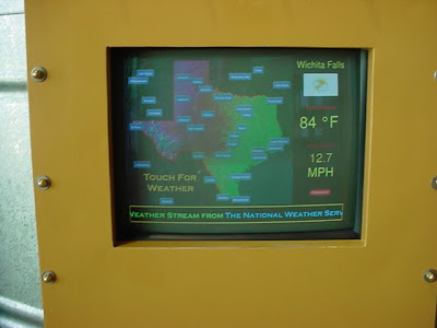
I’ve mentioned these state-of-the-art rest areas in earlier blogs, but I have not provided many pictures of them. So, I provide a few here. They really are nice, clean and safe – except for the rattlesnakes! And as mentioned before, they have interesting history, weather and interactive displays; plus cool architectural treatments, adequate parking, wifi and playgrounds for the kids.


But for me, I still prefer the old style. I don’t have any kids, and I can wait until I get home to check my email.